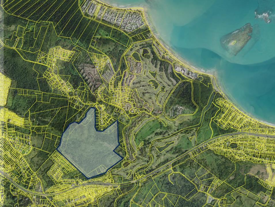
178 Acres in Touristic Sector of Rio Grande
West of Km 0.3, State Road PR-968, Mameyes & Zarzal Wards, Rio Grande 00745
| Land Size | 177.73 Acres |
| Zoning | A-G |

This offering refers to a 178 acres land parcel enjoying a non-floodable classification, an A-G (agricultural) zoning, and an irregular shape with an adequate width-to-depth relationship for any future development. More so, its rolling topography creates stunning views of the Atlantic Ocean and the El Yunque Rainforest. Water and electricity infrastructure is available within the immediate surroundings.
The immediate neighborhood is characterized by the presence of the Rio Mar master-planned community which, located directly across the street from this property, includes among others, the 400-room Wyndham Grand Rio Mar Puerto Rico Hotel, two 18-hole golf courses designed by renown architects, a 35,000 square feet clubhouse, and various luxury villas, apartments and single-family homes, mostly geared towards the second-home nature.
In addition, the Hyatt Regency Grand Reserve Puerto Rico Hotel (Coco Beach) lies about 3 miles northwest from this property, the famous Las Picúas Beach is less than 1.5 miles north, and the Balneario de Luquillo Beach is about 1.5 miles to the east. As such, due to the beachfront character of the neighborhood, the area is strongly characterized by tourism and water-related activities. This is well-complemented by the presence of El Yunque, the only tropical rainforest in the U.S. National Forest System, and specifically located south of the property, across State Road PR-3.
The property is easily accessed by way of State Road PR-968, which in turn is accessed by State Road PR-3, the main artery of the area connecting the capital of the Island, San Juan, with all eastern municipalities. The immediate surroundings include a solid workforce and a lack of new construction.
- Asking Price: $2,745,000 or Best Offer
- Land Area: 183.0023 Cuerdas, equivalent to 177.73 Acres and/or 719,271.61 Square Meters
- Coordinates: Lat: 18.37781203, Lon: -65.77038740
- Shape: Irregular, but providing an adequate width-to-depth relationship for development
- Topography: Level to rolling
- Tax Code #'s (CRIM): 091-097-006-08; -09; -10; -11; & -12
- Flood Classification: X (non-floodable) with a very small portion (less than 1%) labeled 0.2 PCT
- Zoning: A-G (Agricultural)
- Video: https://youtu.be/bACy_P4XFTs?si=-w4cpfgeYv91taBS
The information contained herein is from sources deemed reliable, but is subject to errors, omissions, and withdrawal without notice.


