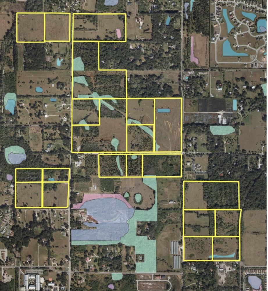
254+- ac Residential Land in Palmetto
2087 37th Street E., Palmetto, Florida 34221
| Land Size | 254 Acres |
| Zoning | A-1, RSF-2 |

PROPERTY DESCRIPTION This assemblage of 254 acres located throughout Palmetto, FL is ideal for an investor or developer. Portions of the property were approved by Manatee County for residential development. The remaining parcels have land use in place for residential development as well. The parcels are all within close proximity to each out with limited wetlands. The parcels are being offered in a bulk sale and will not be sold individually.
DESCRIPTION Parcel A "Monteaux" is located at the northeast corner of 29th Street East and 24th Avenue East (aka Oakhurst Rd) and contains 56.66 gross acres, of which 1.3 acres are wetlands. This property is located on the north side of 29th Street East, a two-lane, asphalt paved and crowned, local road. The western boundary of Parcel A is 24th Avenue East, a two-lane, compacted limestone local road. A portion of the eastern boundary of this site is a CSX railroad line. Surrounding land uses include light industrial, agricultural nursery, residential, and support commercial. This site has a Planned Development-Residential zoning designation and is permitted for 228 single-family residential units.
Parcel B "Bonnieux" is located at the southwest corner of 24th Avenue East and 37th Street East (Mendoza Road). Parcel B contains 24.35 gross acres, with 1.26 acres of wetlands and the remaining 23.09 acres of uplands. Surrounding land uses are predominately undeveloped agricultural acreage.The subject property Parcel B has a Future Land Use designation of Residential-3, and is zoned A-1 and RSF-2.
Parcel C "Courthezon" is located at the northeast corner of 16th Avenue East (Canal Road) and 37th Street East (Mendoza Road). Additionally, the eastern boundary for a portion of Parcel C is 24th Avenue East. Parcel C contains 107.54 gross acres, of which 5.9 acres are wetlands. Parcel C has a Future Land Use designation of Residential-3, and is zoned A-1 and RSF-2, by Manatee County.
Parcel D, "Cadenet" is located at the northwest corner of 16th Avenue East and 33rd Street East. It contains 26.28 acres, of which 0.61 acres are wetlands. The majority of this site is cleared pastureland. There is a single-story building contains approximately 2,500 square feet of heated area and was constructed in 1930. Parcel D has a Future Land Use designation of Residential-3, and is zoned A-1 and RSF-2.
Parcel E, "Winsted" is located on the west side of 16th Avenue East, south of 49th Street East. The parcel is 20.16 acres with a future land use of R-3 and zoned PD-R for 94 residential units consisting of condos, townhomes and single family homes.
Parcel F "Lidia Farm" is located on the east side of 16th Avenue East, across from Parcel E, and south of 49th Street East. Parcel F is rectangular in configuration, containing 19.03 gross acres, of which 0.66 acres are wetlands. Parcel F has a Future Land Use designation of Residential-3, and is zoned RSF-2.
The information contained herein is from sources deemed reliable, but is subject to errors, omissions, and withdrawal without notice.


