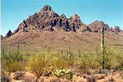
Marana 602 AC
22601 W. Ragged Top Rd, Marana, Arizona 85653
| Land Size | 602 Acres |
| Zoning | RH |
TAX PARCEL # 208-06-003E
PRICE: $2,000.00 per AC
Surrounded on 3 sides (South, East and West) by the 129,000 acre Ironwood Forest National Monument Taking its name from one of the longest living trees in the Arizona desert, the 129,000-acre Ironwood Forest National Monument is a true Sonoran Desert showcase. Keeping company with the ironwood trees are mesquite, palo verde, creosote, and saguaro, blanketing the monument floor beneath rugged mountain ranges named Silver Bell, Waterman and Sawtooth. In between, desert valleys lay quietly to complete the setting.Elevations here range from 1,800 to more than 4,200 feet. Three areas within the monument, the Los Robles Archeological District, the Mission of Santa Ana del Chiquiburitac and the Cocoraque Butte Archeological District, are listed on the National Register of Historic Places.Ragged Top Mountain is the biological and geological crown jewel of the national monument. Several endangered and threatened species live here, including the Nichols turk’s head cactus and the lesser long-nosed bat. The national monument also contains habitat for the cactus ferruginous pygmy owl. The desert bighorn sheep dwelling in the region are the last viable population indigenous to the Tucson basin. The area holds abundant rock art sites and other archaeological objects of scientific interest. Humans have inhabited the area for more than 5,000 years. More than 200 sites from the prehistoric Hohokam period (600 A.D. to 1440 A.D.) have been recorded in the area. In more modern times, the area was a source of minerals and continues to support active mining operations today.Hiking, mountain biking, wildlife and plant viewing, horseback riding, photography, sightseeing, wildflower viewing in spring, hunting, birdwatching, fossil and geologic sightseeing, historic and archaeological sites. Directions: NW of TUCSON From Tucson, take Interstate 10 west to Marana. Take Exit 236, turn left on Sandario Road for .1 mile, then turn right on Marana Road and go west about 5.8 miles to Silver Bell Road. Continue on Silver Bell Road to Ragged Top Rd follow Ragged Top Rd. to pipe line, property is on left.
The information contained herein is from sources deemed reliable, but is subject to errors, omissions, and withdrawal without notice.

