22+/- Acres US 1 Titusville
5400 S. Washington Avenue, Titusville, Florida 32780
| Land Size | 21.57 Acres |
| Zoning | RC-Regional Commercial |

9.24± Acre Parcel
Parcel ID – 22-35-26-00-00518.0-0000.00
Flood Zone X
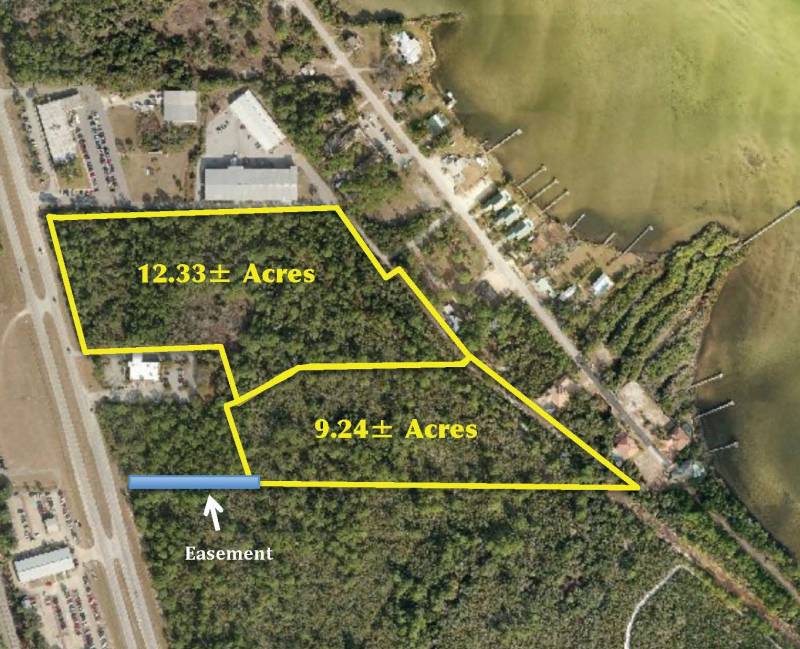
This flat and level parcel lies to the rear of a 1.31-acre tract of different ownership. An easement
over this tract to Hwy US 1 provides access (62’ x 417’). The unimproved easement is located at the southwest corner of the 9.24 acres. Brevard County Natural Resources Map disclosed no wetland on this parcel.
12.33± Acre Parcel
Parcel ID – 22-35-26-00-00504.0-0000.00
Flood Zone X
This flat and level parcel contains approximately 10.78 acres of uplands and 1.55 acres of wetlands.
453’ frontage on US Hwy 1.
LOCATION - Both properties are located just east of Washington Ave. (US Hwy 1) at the extreme south end of Titusville. Properties lie approximately ½ mile south of Cheney Hwy. (SR 50) and 1 mile north of Columbia Blvd. (SR 405). Both properties are zoned RC – Regional Commercial.
The information contained herein is from sources deemed reliable, but is subject to errors, omissions, and withdrawal without notice.


